Description
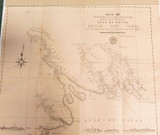
RARE 1896 Colonial British New Guinea Large Map. Mambare River to Gosisi Village
Super rare, unable to find another for sale or in any archives. 100% genuine & not a reproduction. A Sketch Plan Map by Sir William MacGregor dated 1896. Printed by Edmund Gregory, Government Printer, William Street, Brisbane, QLD. The map depicts The Sketched Plan traversed from the Mambare Mouth to the Village of Gosisi on the Vanapa. Large folding map hinged to acid free white board. Looks far better than the photos depict. Measures 47cms x 39cms. Some minor tears along the fold lines & to the edges, some small losses along the fold lines, some minor foxing. Will be posted flat to avoid damage.
Local Brisbane pick-up welcomed. Always happy to combine postage where possible & practical. HNCO are not responsible for import duties or customs charges. This is the buyers / importers responsibility.
_gsrx_vers_854 (GS 7.0.18 (854))


